|
|
A
History
of
the
Railways |
|
|
by Christopher J Tolley |
||
|
||||||
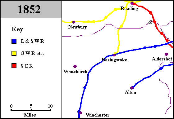
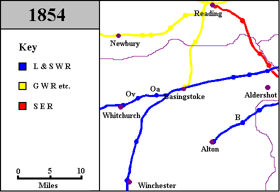
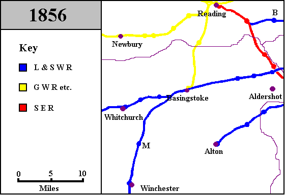
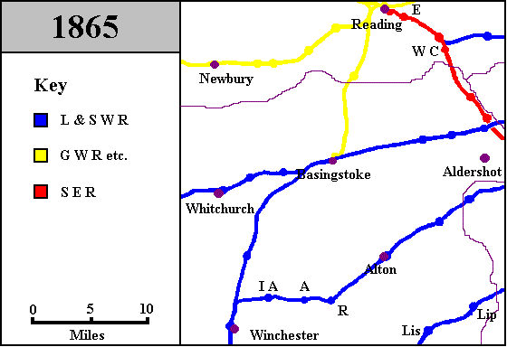
Basingstoke 's Railway History in Maps
One of the easiest ways to show the development of a railway network in a particular area is by means of a series of chronological maps. The maps below are centred on Basingstoke, with Reading in the north and Winchester in the south, these being the nearest large towns connected by rail. Though each of these extremities is only twenty minutes or so away from Basingstoke by train in 1995, the result is that the maps cover about 1,000 square miles and eighty or so significant locations.
Each map represents the railway network at the end of the year shown on it. (Some features came and went in the same year, like Sandhurst Halt in 1852; these are shown as if they still existed at the end of the year.) Intervals between succeeding maps depend on the amount of change taking place. A line opening or closing usually merits a new map for the relevant year. Other events are shown in the notes on each map, and may have taken place at any time since the date of the preceding map.
These maps are annotated to show opening and closure dates, as well as changes of name (other than the addition or subtraction of the word "Halt") and other events of significance. Asterisks indicate the presence of footnotes to the annotations.
|
|
|
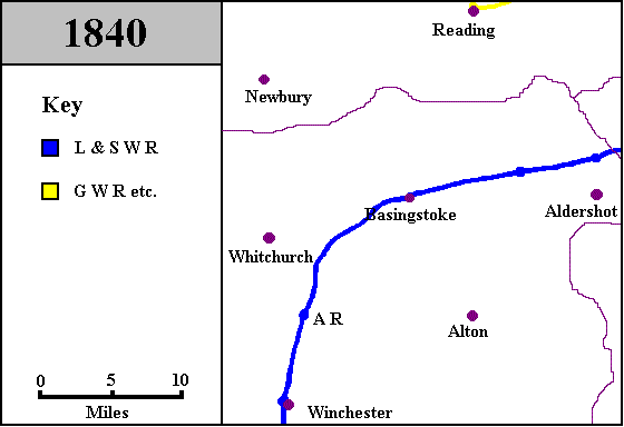
In 1820, there were as yet no public railways in Hampshire. This map establishes the locations which will appear in each of the subsequent maps. The counties are coloured here and named, but these devices are not used on later maps, though the county borders do remain. On subsequent maps, stations are marked by blobs on the lines, and when these stations first appear on the maps, letters are used in conjunction with a key beneath each map to indicate the name of each station. |
|
|
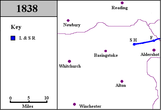
|
F 24 Sep 1838 opening: Farnborough {L&SR}* SH 24 Sep 1838 opening: Shapley Heath* * {L&SR} Stations of different companies serving the same place were not always given distinguishing names. In such cases, I have used the convention of showing the initials of the owning company in braces. I emphasise that these initials were not part of the official names of the stations concerned. So, in this case, the London and Southampton Railway opened the first station called Farnborough. N.B. In some early publicity, the station was called "Farnborough for Aldershot". * Shapley Heath Every railway history book I have consulted records that the station was called Shapley Heath when opened, and on the map I have shown it as such. However, in an 1840 ticket price list, it is called Winchfield, as indeed it is today. A mural on the station calls it Winchfield and Hartley Row, which I suspect to be a mistake, as the Hampshire Chronicle report of the first train to Basingstoke calls this station Winchfield and Shapley Row. It seems likely to me that while the line was still being constructed, either there had been no final decision as to the name, or that local people used one name while officialdom used another. No date for the "renaming" to Winchfield can therefore be given. |
|
|
|
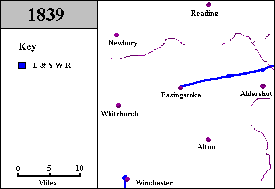
1839 renaming: L&SR becomes L&SWR* 10 Jun 1839 opening: Winchester 10 Jun 1839 opening: Basingstoke{L&SWR} * L&SWR The London and Southampton Railway was renamed "The London and South Western Railway" as a result of its expansion plans. The first branch from the main line was planned to run from Bishopstoke (later renamed Eastleigh) to Gosport. It opened on 29 November 1841. |
|
|
|
30 Mar 1840 opening: Reading {GWR} AR 11 May 1840 opening: Andover Road* * Andover Road. This station was the only one which has been open to the public between Basingstoke and Winchester. At the time it was built, it served no settlement of note, and although it was nominally for passengers bound for Andover, it is a good ten miles from that town. The road in the name was a turnpike called Galiker Way. When the railway did eventually reach Andover, this station was renamed as Micheldever, (see note on 1856 map). |
|
|
|
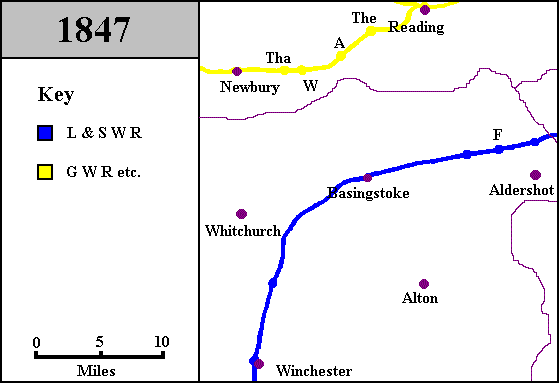
F May 1847 opening: Fleetpond* 21 Dec 1847 opening: Newbury* The 21 Dec 1847 opening: Theale A 21 Dec 1847 opening: Aldermaston W 21 Dec 1847 opening: Woolhampton* Tha 21 Dec 1847 opening: Thatcham * Fleetpond See note on 1870 map. The Pond at Fleet is a shallow lake. One source I have consulted remarks that Londoners came to Fleet to skate on the Pond when it was frozen. This is the kind of anecdote that one usually has doubts about, but I can vouch for the fact that during the cold spell at the start of 1997, the Pond was indeed frozen. Thus it is quite possible that it attracted skating tourists in the 1800's. (Mind you, I didn't see any in 1997!) * Newbury The map shows the line from Reading to Newbury as "GWR etc." The company which promoted the line was the Berks and Hants Railway. Although this might appear to be an independent concern, it was financed by the GWR, and was formally absorbed into it in 1846. * Woolhampton See note on 1882 map. |
|
|
|
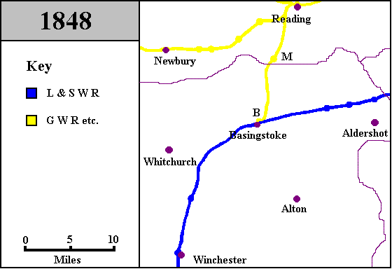
M 1 Nov 1848 opening: Mortimer* B 1 Nov 1848 opening: Basingstoke {GWR} * Mortimer etc. The line between Reading and Basingstoke was originally promoted by the Berks & Hants Railway, which, as noted previously, was absorbed by the GWR before the service began to operate. |
|
|
|
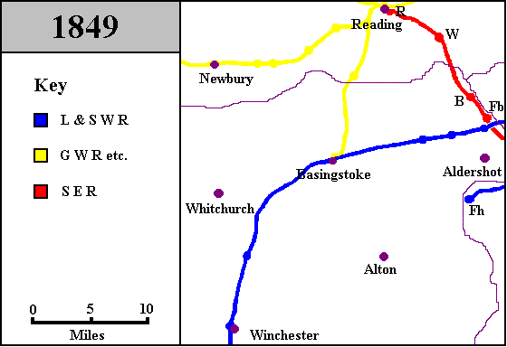
W 4 Jul 1849 opening: Wokingham B 4 Jul 1849 opening: Blackwater Fb 4 Jul 1849 opening: Farnborough {SER}* R 4 Jul 1849 opening: Reading {SER} Fh 8 Oct 1849 opening: Farnham* * {SER} South Eastern Railway. The London terminus of the SER was Charing Cross, and the route thence to Reading was, to say the least, circuitous. En route, a traveller would pass through Croydon, Red Hill, Dorking, Guildford and Wokingham. The distance from Charing Cross to Reading is 68¾ miles. This compares with 36 from Paddington! * Farnham The line was opened from Guildford, but the original route was via Tongham and Ash Green, not Aldershot. See note on 1938 map. |
|
|
|
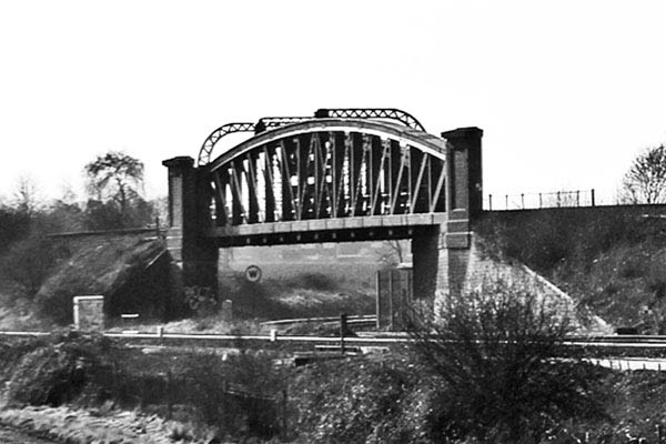
1851 rebuilding: Basingstoke {L&SWR} station* Aug 1851 renaming: Blackwater & Sandhurst (formerly Blackwater) S 4 May 1852 opening: Sandhurst Halt* Jun 1852 renaming: Blackwater (formerly Blackwater & Sandhurst) 28 Jul 1852 opening: Alton 31 Dec 1852 closure: Sandhurst Halt * Basingstoke This is the latest date for the rebuilding of the station. I have not discovered a source which provides the exact date. The previous station was still standing in 1848. * Sandhurst This was a temporary platform. It is not certain that it was open to the public. |
|
|
|
B Jul 1854 opening: Bentley Oa 3 Jul 1854 opening: Oakley Ov 3 Jul 1854 opening: Overton 3 Jul 1854 opening: Whitchurch |
|
|
|
1856 opening: Reading West Curve* M Feb 1856 renaming: Micheldever (formerly Andover Road) B 9 Jul 1856 opening: Bracknell 22 Dec 1856 line opening: Mixed gauge from Reading to Basingstoke* * West Curve This is a short connection from Oxford Road Junction, just north of the current Reading West station to Reading West Junction, on the GWR main line. This forms a triangle of railway lines, within which the Reading maintenance depot may be found. * Mixed Gauge The GWR opened their lines originally with a gauge (the separation of the rails) of seven feet and a quarter inch - the design of their engineer I K Brunel. The vast majority of the other railways were built to Stephenson's standard gauge of four feet eight and a half inches. The difference in gauges made it impossible to run trains from one company on the tracks of another. The early solution to this problem was to install a third rail between the broad gauge rails, at the standard gauge distance from one of the others. Such track was called mixed gauge. |
|
|
|
Lis 1 Jan 1859 opening: Liss* Lip 1 Jan 1859 opening: Liphook* WC 29 Jan 1859 opening: Wellington College* E Nov 1863 opening: Earley 2 Oct 1865 rebuilding: Alton* IA 2 Oct 1865 opening: Itchen Abbas A 2 Oct 1865 opening: Alresford R 2 Oct 1865 opening: Ropley * Liss, Liphook These stations are on the route from Woking to Havant. This is known as the Portsmouth Direct route, being the shortest from London to that port. * Wellington College See note on 1932 map. * Alton When the line was extended to Winchester, a new station was built in Alton, about 100 metres from the original one. The original building survived for 100 years or so, before being demolished when the car park was being enlarged. |
|
|
|
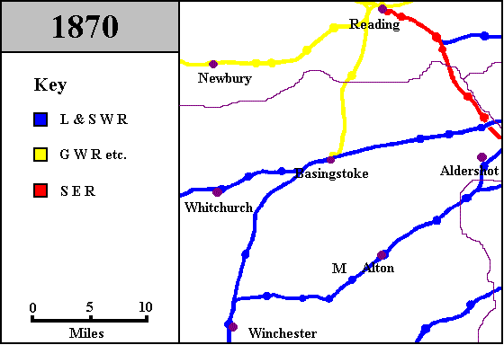
M Aug 1868 opening: Medstead 1869 line closure: Broad gauge rail removed Reading to Basingstoke 1 Jul 1869 renaming: Fleet (formerly Fleetpond) 2 May 1870 opening: Aldershot |
|
|
|
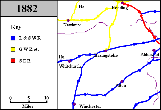
1 Mar1873 renaming: Midgham (formerly Woolhampton) He 13 Apr 1882 opening: Hermitage* Hu 1 Dec 1882 opening: Hurstbourne * Hermitage This was on the first section of the Didcot, Newbury and Southampton Railway to be opened. Like the Berks & Hants, the DN&SR was backed by the GWR. However, unlike the B&H, the DN&SR did remain a separate company until 1923. |
|
|
|
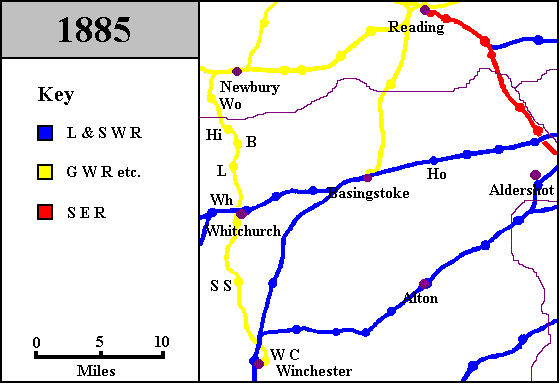
Ho 2 Jul 1883 opening: Hook Wo 4 May 1885 opening: Woodhay Hi 4 May 1885 opening: Highclere B 4 May 1885 opening: Burghclere L 4 May 1885 opening: Litchfield Wh 4 May 1885 opening: Whitchurch Town SS 4 May 1885 opening: Sutton Scotney WC 4 May 1885 opening: Winchester Cheesehill* 1
Jun
1885
line
opening:
Northern
&
Southern
Junction
Railway,
Hurstbourne
to * N&SJR Northern and Southern Junction Railway The name suggests a grander line than this. Fullerton lay less than ten miles south-south-west of Hurstbourne, on the line between Andover and Romsey. There were stations at Longparish and Wherwell. As a passenger carrier, it was unsuccessful, but other uses were found for it later - there was an ammunition dump at Longparish in World War 2, and after that, the Longparish - Fullerton section was used as a test track for new rolling stock during the 1950's. * Cheesehill See note on 1950 map. |
|
|
|
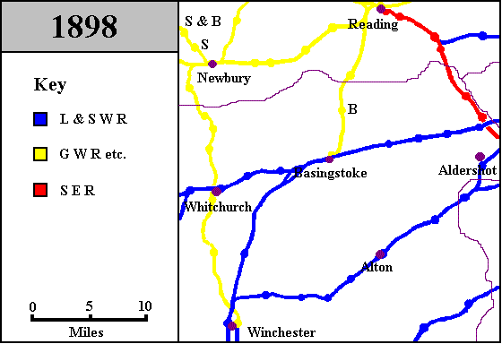
4 Sep 1891 line opening: Winchester Cheesehill to Shawford Junction* B 1 May 1895 opening: Bramley May 1897 renaming: Blackwater & York Town (formerly Blackwater) 30 May 1897 commissioning: Battledown flyover* S&B 4 Apr 1898 opening: Stockcross & Bagnor* S 4 Apr 1898 opening: Speen* * Cheesehill branch The L&SWR built and owned this connection, but the DN&SR had running powers over it. * Battledown This flyover, 3¼ miles west of Basingstoke, is represented by the loop on the map. It carries the northbound track from Winchester over both the tracks on the Salisbury line. This was one of a number of projects carried out at about this time by the L&SWR with a view to making the main line more suitable for high-speed running. * Stockcross, Speen These two stations were on the line from Newbury to Lambourn. This was opened by the Lambourn Valley Railway, but this railway was never financially successful, and was taken over by the GWR on 1 July 1905. The station at Stockcross & Bagnor may for a while have been called Stockcross. |
|
|
|
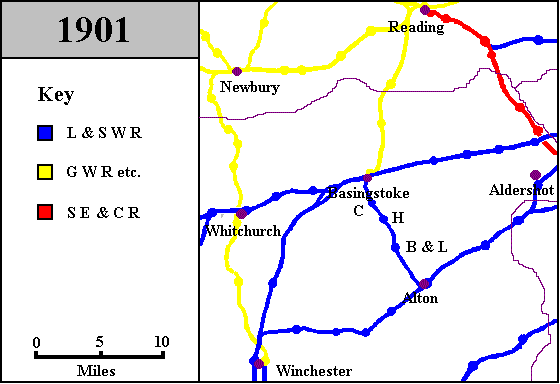
1 Aug 1899 renaming: SER joins with LC&DR to form SE&CR* 1900 opening: Thornycroft's private siding, Basingstoke. H 1 Jun 1901 opening: Herriard B&L 1 Jun 1901 opening: Bentworth & Lasham C 1 Jun 1901 opening: Cliddesden * LC&DR London, Chatham and Dover Railway. The LC&DR started off as the East Kent Railway, and attempted to form an alliance with the SER. Suitable terms could not be agreed, so putative cooperation developed into competition, and bordered on feuding at times. The LC&DR suffered from a shortage of large towns on its route, and a surfeit of engineering works because of the Downs - although the Downs are by no means mountains, they do form quite a substantial natural barrier to any railway running north to south. Never well-off, the fight with the SER left it on the verge of bankruptcy on more than one occasion. Eventually, an accommodation was reached, and the two railways began to work together under the title "South Eastern and Chatham Railway Companies' Joint Management Committee". |
|
|
|
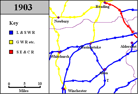
T 1 Jun 1903 opening: Tisted* * Tisted Also opened was a goods station at Farringdon. This station appears on the 1938 map, when it was opened to passengers. |
|
|
|
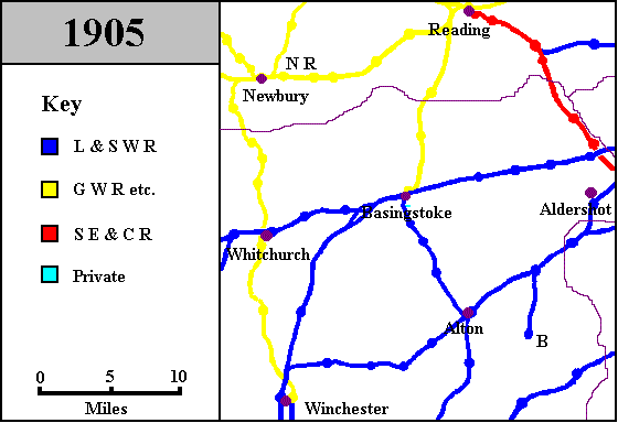
NR 26 Sep 1905 opening: Newbury Racecourse* B 11 Dec 1905 opening: Bordon * Newbury Racecourse This station was originally opened for special trains on race days only. It did not appear in public timetables until 1912, and even then was only for race traffic. At the end of the 1980's, a conference and banqueting suite was built at the racecourse, and since 1990, an "experimental" service has been operated to the station on a regular basis. (During the 1980's and 1990's, a handful of lines and stations have been reopened as experimental services in various parts of Great Britain. Services operated on an experimental basis may quickly be withdrawn without recourse to the statutory closure procedure for standard services. One example of an experimental service which has come and gone is Kettering to Corby, roughly 70 miles north of the area covered by these maps.) |
|
|
|
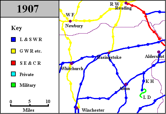
KH 7 Mar 1906 opening: Kingsley Halt RW 1 Jul 1906 opening: Reading West WF 1 Oct 1906 opening: Newbury West Fields LD 1907 opening: Longmoor Downs* * Longmoor. Only the major (no pun intended) alterations in the layout of the Longmoor Military Railway are represented in these maps. See the maps of 1933, 1941 and 1969. |
|
|
|
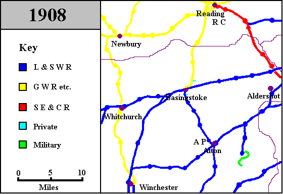
AP 1908 opening: Alton Park RC 4 May 1908 opening: Reading Central* Nov 1908 opening: Daneshill Brick & Tile Works siding * Alton Park This was a private halt, built in connection with the Lord Mayor Treloar's Hospital at Alton. With the exception of a final enthusiasts' special, the only passenger trains which called here carried hospital patients. In addition to the passenger platform, there was also a siding for delivery of coal, which was on quite a steep gradient (at this point the Basingstoke and Alton Light Railway is on an embankment, but the boiler to which the coal was taken was at ground level). At various stages, these were also called "Treloar's Hospital Platform" and "Cripples' Home Siding". * Reading Central This was a goods-only station. The track leading to it was called the Coley Branch, and was about 1¼ miles long. An extension ran to Bear Wharf, on the River Kennet. |
|
|
|
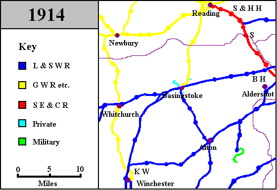
S 1909 opening: Sandhurst KW 1 Feb 1909 opening: Kings Worthy S&HH 1 Jan 1910 opening: Sindlesham & Hurst Halt* BH 1 May 1913 opening: Bramshot Halt* 1 Jun 1913 renaming: Blackwater & Camberley (formerly Blackwater & York Town) Feb 1914 opening: Park Prewett* * Sindlesham see note on 1932 map. * Bramshot This halt served the adjacent golf course. Until 3 Jul 1938, only members were allowed to use it. The name was spelt Bramshott on tickets and Bramshot in the timetable. * Park Prewett, Basingstoke. Opened for goods only. |
|
|
|
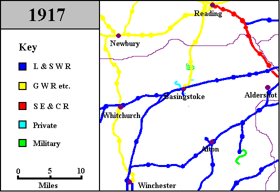
30 Dec 1916 closure: Herriard 30 Dec 1916 closure: Bentworth & Lasham 30 Dec 1916 closure: Cliddesden 1917 opening: Bramley MoD* Aug 1917 line removed: Cliddesden to Alton Park - taken to France for war use * Bramley MoD This railway was built to serve an ordnance store. (MoD is short for Ministry of Defence.) The layout shown on this map approximates to its largest extent, which was not actually in place until rather later. |
|
|
|
WD 1 Apr 1918 opening: Worthy Down Halt 9 Jul 1923 renaming: Blackwater (formerly Blackwater & Camberley) 9 Jul 1923 renaming: Farnborough North (formerly Farnborough) 18 Aug 1924 reopening: Herriard 18 Aug 1924 reopening: Bentworth & Lasham 18 Aug 1924 reopening: Cliddesden * SR, GWR The majority of the railways in the Great Britain were grouped into four companies, the Southern Railway, the Great Western Railway, the London, Midland and Scottish Railway and the London and North Eastern Railway. Although it kept its name, the GWR was significantly enlarged by the accretion of twenty or so other companies. *
Winchester
In
the
Winchester
area,
there
were
two
short-lived
military
installations.
There
was
a
troop
platform
on
the
main
L&SWR
line
from
Nov
1918
to
some
time
in
1919,
and
there
was
also
a
short
branch
from
the
DN&SR
to
an
encampment
in Avington
|
|
|
|
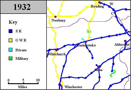
C 12 Jun 1927 renaming: Crowthorne (formerly Wellington College) W 7 Jun 1930 renaming: Winnersh (formerly Sindlesham & Hurst Halt) 1 Jan 1932 closure: Basingstoke (GWR)* 12 Sep 1932 closure to passengers: Herriard 12 Sep 1932 closure to passengers: Bentworth & Lasham 12 Sep 1932 closure to passengers: Cliddesden Sep 1932 line closure Bentworth and Lasham to Alton Park * Basingstoke This date marks the end of separate staffing by GWR personnel. GWR train services continued largely unaltered. |
|
|
|
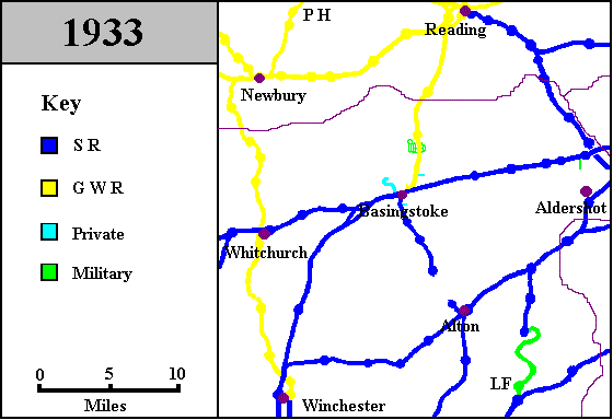
LF 1933 opening: Liss Forest (LMR) PH 11 Sep 1933 opening: Pinewood Halt |
|
|
|
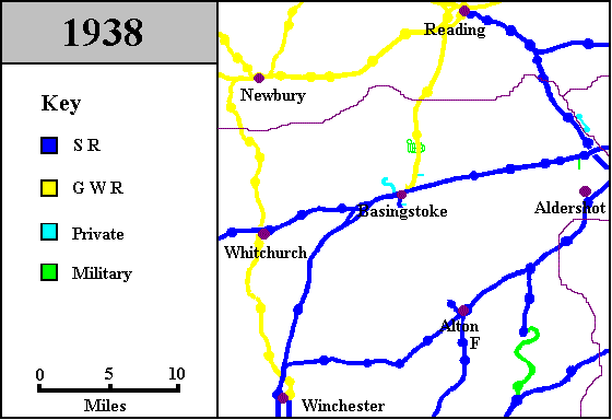
May 1934 line closure: Hurstbourne to Longparish F 1 May 1935 opening: Farringdon 1 Jun 1936 closure to goods: Herriard 1 Jun 1936 closure to goods: Bentworth & Lasham 1 Jun 1936 closure to goods: Cliddesden Jun 1936 line closure: Bentworth and Lasham to a point just south of the Thorneycroft siding at Basingstoke. 4 Jul 1937 line closure: Ash Junction to Farnham Junction 1 Oct 1937 renaming: Medstead & Four Marks (formerly Medstead) 23 Jul 1938 opening: Surrey Border & Camberley Railway* * SB&CR This was a narrow-gauge railway, built primarily to carry tourists. |
|
|
|
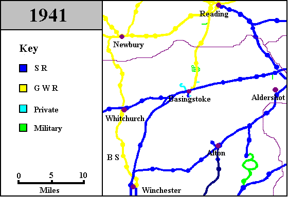
4 Sep 1939 closure: Surrey Border & Camberley Railway 1940 opening: Burghfield Royal Ordnance Factory siding near Reading BS Feb 1940 opening: Barton Stacey Halt* 1941 opening: Hollywater Loop, Longmoor Military Railway Dec 1941 closure: Barton Stacey Halt * Barton Stacey Opened to serve an army base. |
|
|
|
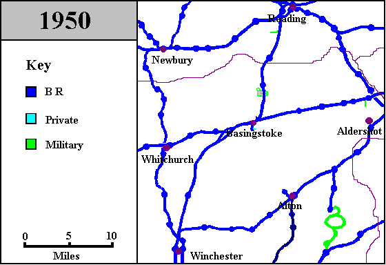
5 Mar 1942 line opening: Winchester Junction to Worthy Down* 4 Aug 1942 line closure: Didcot to Winchester Cheesehill* 31 Dec 1942 closure: Daneshill Brick & Tile Works 8 Mar 1943 line reopening: Didcot to Winchester Cheesehill* 1946 closure: Bramshot Halt 26 Sep 1949 renaming: Reading Southern (formerly Reading) 26 Sep 1949 renaming: Whitchurch North (formerly Whitchurch) 26 Sep 1949 renaming: Winchester City (formerly Winchester) 26 Sep 1949 renaming: Winchester Chesil (formerly Winchester Cheesehill) 30 Sep 1950 closure: Park Prewett* * BR British Railways. The four companies which had been created in 1923 were amalgamated into British Railways on 31 December 1948. In fact, this did not have much of an effect for quite a while. On the one hand, there was already state control of the railways since the outbreak of the Second World War, so centralised management was nothing new. On the other, the nationalised railway was organised on a regional basis, with the regional boundaries generally being drawn in the same places as the boundaries between the earlier companies. * Winchester The temporary closure of the former DN&SR was to allow track to be doubled over much of its length. The short line to Worthy Down was only for northbound trains (those going south were routed via Winchester Cheesehill, now named Winchester Chesil). * Park Prewett This was the effective date of closure, when trains were banned from the line. Official closure took place in 1954, and track lifting in 1956. |
|
|
|
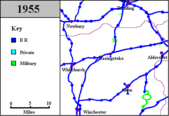
Nov 1951 line closure: Winchester Junction to Worthy Down* 7 Feb 1955 closure: Tisted 7 Feb 1955 closure to passengers: Farringdon * WinchesterThis connection fell out of use as a through route soon after the end of the war, and was used for some years after this date for carriage and wagon storage. The line was eventually taken up in Feb 1957. |
|
|
|
1957 closure: Burghfield R O F siding 16 Sep 1957 closure to passengers: Bordon 16 Sep 1957 closure to passengers: Kingsley Halt 4 Jan 1960 closure: Stockcross & Bagnor 4 Jan 1960 closure: Speen 4 Jan 1960 closure: Newbury West Fields 7 Mar 1960 closure to passengers: Woodhay 7 Mar 1960 closure to passengers: Highclere 7 Mar 1960 closure to passengers: Burghclere 7 Mar 1960 closure to passengers: Litchfield 7 Mar 1960 closure to passengers: Whitchurch Town 7 Mar 1960 closure to passengers: Sutton Scotney 7 Mar 1960 closure: Worthy Down Halt 7 Mar 1960 closure to passengers: Kings Worthy 7 Mar 1960 closure to passengers: Winchester Chesil 13 Aug 1962 closure to goods: Litchfield 10 Sep 1962 closure: Hermitage 10 Sep 1962 closure to passengers: Pinewood Halt 10 Oct 1962 closure to goods: Kings Worthy 31 Dec 1962 closure to goods: Woodhay 31 Dec 1962 closure to goods: Highclere 6 May 1963 closure to goods: Burghclere 6 May 1963 closure to goods: Whitchurch Town 17 Jun 1963 closure: Oakley |
|
|
|
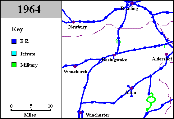
6 Apr 1964 closure: Hurstbourne 10 Aug 1964 closure to goods: Pinewood Halt 10 Aug 1964 line closure: Didcot to Newbury 10 Aug 1964 line closure: Winchester Chesil to Newbury |
|
|
|
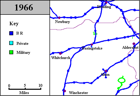
6 Sep 1965 closure: Reading South* 4 Apr 1966 closure to goods: Winchester Chesil 4 Apr 1966 line closure: Bentley to Bordon 4 Jun 1966 line closure: Winchester Chesil to Shawford Junction 12 Nov 1966 commissioning: colour light signalling Worting to St.Denys 19 Nov 1966 commissioning: Basingstoke Power Signal Box 19 Nov 1966 commissioning: colour light signalling Brookwood to Andover * Reading A new platform was brought into use at the former GWR station and services from London Waterloo and Guildford were diverted to that station. |
|
|
|
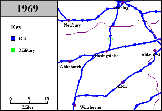
1967 closure: Alton Park 1967 closure: Thornycroft's Siding 1 Jan 1967 electrification: Brookwood to Basingstoke 3 Apr 1967 electrification: Basingstoke to Bournemouth 10 Jul 1967 renaming: Winchester (formerly Winchester City) Aug 1968 closure to goods: Farringdon 31 Oct 1969 line closure: Longmoor Military Railway |
|
|
|
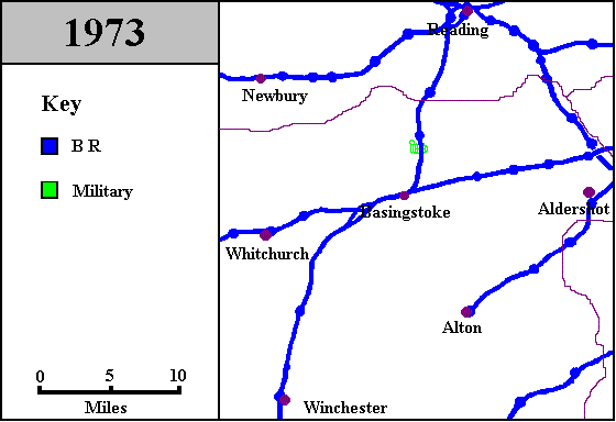
2 Oct 1972 renaming: Whitchurch (formerly Whitchurch North) 5 Feb 1973 closure: Itchen Abbas 5 Feb 1973 closure: Alresford 5 Feb 1973 closure: Medstead & Four Marks 5 Feb 1973 closure: Ropley Feb 1973 line closure: Alton to Winchester Junction 5 Nov 1973 line closure: Welford Park - Newbury |
|
|
|
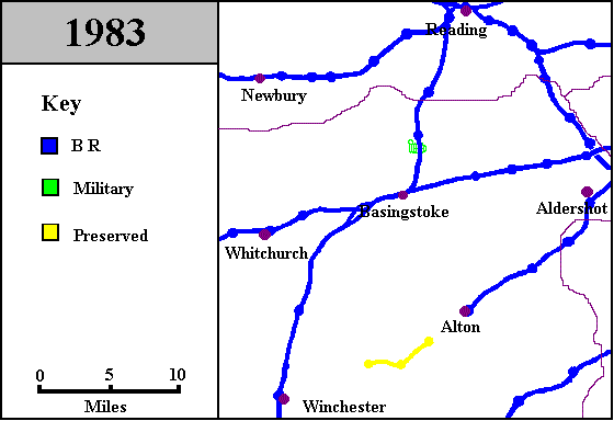
30 Apr 1977 reopening: Alresford* 30 Apr 1977 reopening: Ropley* * Alresford/Ropley This stretch of track was reopened privately by the Mid-Hants Railway (otherwise known as the Watercress Line). |
|
|
|
28 May 1983 reopening: Medstead & Four Marks 25 Jul 1983 closure: Reading Central |
|
|
|
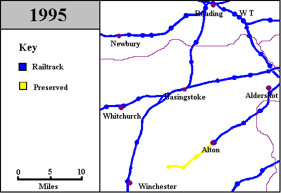
25 May 1985 line reopening: Medstead & Four Marks to Alton |
|
|
|
2 Mar 1987 closure: Bramley MoD WT 11 May 1987 opening: Winnersh Triangle |
Click here to return to the table of contents for Basingstoke's Railway History
|
This
article
is
a
part
of
the
Basingstoke
&
District
Railway
Society
website. |